
The South West Coast Path, often abbreviated to SWCP, is Britain’s longest National Trail – at least until the England Coast Path is complete. The SWCP itself makes up part of the England Coast Path, and as such was one of the earliest chunks to be in place.
The South West Coast Path was opened as a National Trail in 1978. It’s 630 miles or 1,014 km long making it more than double the length of the next longest. It’s a mighty undertaking to walk this trail, and would usually take a couple of months if doing it in one go. Many, however, largely because it is so big, do it in sections over a much longer period, which is what I did.
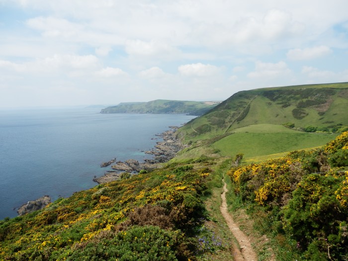
The trail officially starts in Minehead in Somerset and heads anti-clockwise around the coasts of Somerset, Devon, Cornwall, Devon again and Dorset to an end at South Haven Point near Poole. As you would expect from a coastal trail, it’s a walk of lots of cliffs, beaches, town seafronts and the like. It’s one National Trail you can pretty much guarantee getting an ice cream every day.
In places the trail covers some quite rugged terrain, and it is common for a day on the Path to involve big descents followed immediately by a big reascent, then a short respite of walking over a headland, before doing it all again. A day walking the South West Coast Path will typically equate to as much ascent and descent as a day walking in the Lake District, for example. It’s not an easy trail.
My Walk of the Trail
In a conversation with my father in 2007 we talked about doing some walking on the Dorset coast, scene of several childhood family holidays. Realising the the SWCP covered all of the area we were looking at, the idea morphed into doing the path itself, although originally we were only really looking at that first stretch and had no firm plans to do the whole thing.
The 4 days my father, brother and I did in June 2008 were hot and sunny and it was a great few days walking – so much so that we decided to continue with the path and to do it in annual chunks. 2008’s walk was followed by sections in 2009, 2010, 2011, 2012, 2013, 2014, 2015, 2016, 2019 and 2023.


The table below shows all of the walks in the order of the path from Poole (South Haven Point) to Minehead – so technically walking it backwards.
Where we bailed out and left a gap, the subsequent return to fill that gap in is in italics. Similarly, additional walks along the coast path that weren’t part of the main project are shown, but also in italics. Where a section was walked backwards, it is still shown in the main order, but the fact it was walked backwards is indicated in the “To” column. The write-up for each day’s walk can be found by clicking on the date.
| Section | From | To | Distance | Accommodation | Date Walked |
|---|---|---|---|---|---|
| 1 | South Haven Point | Swanage | 12.2 km | The Limes, Swanage | 06 June 2008 |
| 2 | Swanage | Kimmeridge | 21.1 km | Blackmanston Farm (***) | 07 June 2008 |
| 3 | Kimmeridge | Lulworth | 13.5 km | Burngate Farm, West Lulworth | 08 June 2008 |
| 4 | Lulworth | Weymouth | 19.1 km | Sunbay Guest House, Weymouth | 09 June 2008 |
| 5 | Weymouth | Portland Bill | 16.2 km | Old Bill House, Portland Bill | 14 May 2009 |
| 6 | Portland Bill | East Fleet | 17.3 km | Heathwick House, Chickerell | 15 May 2009 |
| 7 | East Fleet | Burton Bradstock | 23.6 km | Old Pottery Annexe, Burton Bradstock (basic but excellent value) | 16 May 2009 |
| 8a | Burton Bradstock | Lyme Regis (stopped at Seatown) | 9.9 km (to Seatown) | Smugglers B&B Lyme Regis | 17 May 2009 |
| (8b | West Bay | Lyme Regis | 18.2 km | Campsite near Chard, Somerset | 02 Sept 2014) |
| 9 | Lyme Regis | Branscombe | 17.2 km | Masons Arms, Branscombe (£) | 18 May 2009 |
| 10 | Branscombe | Sidmouth | 10.8 km | n/a | 19 May 2009 |
| 11 | Sidmouth | Budleigh Salterton | 10.7 km | Appletree Cottage, Budleigh Salterton | 13 May 2010 |
| 12 | Budleigh Salterton | Teignmouth | 23.6 km | Ringmore Lodge, Teignmouth | 14 May 2010 |
| 13 | Teignmouth | Torquay | 17.1 km | Ashleigh House B&B, Torquay | 15 May 2010 |
| 14 | Torquay | Brixham | 17.2 km | Sea Tang House, Brixham | 16 May 2010 |
| 15 | Brixham | Dartmouth (Kingswear) | 12.3 km | n/a | 17 May 2010 |
| 16 | Dartmouth | Torcross | 16.1 km | Waterside B&B, Torcross | 18 May 2011 |
| 17 | Torcross | Salcombe | 21.4 km | Waverley B&B, Salcombe | 19 May 2011 |
| 18 | Salcombe | Bantham | 19.0 m | The Sloop PH (£) | 20 May 2011 |
| 19 | Bantham | River Erme | 15.1 km | Little Orcheton Farm (*) | 21 May 2011 |
| 20 | River Erme | River Yealm | 21.6 km | Travelodge, Plymouth (xxx) | 22 May 2011 |
| 21 | River Yealm | Plymouth | 19.8 km | Travelodge, Plymouth (xxx) | 23 May 2011 |
| 22 | Plymouth | Crafthole | 25.8 km | Liscawn Inn, Crafthole | 19 May 2012 |
| 23 | Crafthole | Looe | 15.4 km | Pencarrow Guest House, Looe (2012) Little Harbour, Looe (2013) | 20 May 2012 |
| 24 | Looe | Fowey | 20.3 km | Well House B&B, Fowey (**) (2012, 2013) | 21 May 2012 and 23 June 2013 |
| (24a | Looe | Talland Bay | 12.1 km | Holiday home in Looe | 21 April 2019) |
| 25a | Fowey | Par | 12.0 km | n/a | 22 May 2012 |
| 25b | Fowey | St Austell | 18.1 km | Pen Star Guest House, St Austell (xxx) | 24 June 2013 |
| 26 | St Austell | Gorran Haven | 15.0 km | Swiftsure, Gorran Haven (***) | 25 June 2013 |
| 27 | Gorran Haven | Portscatho | 19.7 km | Trewithian Farm | 26 June 2013 |
| 28 | Portscatho | Falmouth | 21.4 km | Braemar GH, Falmouth | 07 Sept 2014 |
| 28a | Falmouth | Falmouth | 5.7 km | Braemar GH, Falmouth | 06 Sept 2014 |
| 29 | Falmouth | St Keverne | 21.4 km | White Hart (PH), St Keverne | 08 Sept 2014 |
| 30 | St Keverne | Kuggar | 14.1 km | Lyndale Cottage GH, Helston | 09 Sept 2014 |
| 31 | Kuggar | Mullion | 18.5 km | Lyndale Cottage GH, Helston | 10 Sept 2014 |
| 32 | Mullion | Portheven | 12.1 km | Carnson House, Penzance (x) | 11 Sept 2014 |
| 33 | Porthleven | Praa Sands | 6.8 km | Carnson House, Penzance (x) | 12 Sept 2014 |
| 34 | Praa Sands | Penzance | 15.0 km | Whiteways GH, Penzance (x) | 01 June 2015 |
| 35 | Penzance | Porthcurno | 19.2 km | Whiteways GH, Penzance (x) | 02 June 2015 |
| 36 | Porthcurno | St Just | 18.6 km | Whiteways GH, Penzance (x) | 03 June 2015 |
| 37 | St Just | Zennor (walked in reverse) | 21.4 km | Whiteways GH, Penzance (x) | 04 June 2015 |
| 38 | Zennor | St Ives | 10.9 km | n/a (2015) Lord Ryans, St Ives (2016) | 05 June 2015 |
| 39 | St Ives | Gwithian | 18.6 km | Nanterrow Farm (*) | 03 May 2016 |
| 40 | Gwithian | Portreath | 14.6 km | Portreath Arms, PH | 04 May 2016 |
| 41 | Portreath | Perranporth | 19.7 km | Seiners Arms, Perranporth (x) | 05 May 2016 |
| 42 | Perranporth | Newquay | 16.7 km | Griffin Inn, Newquay (x) | 06 May 2016 |
| 43 | Newquay | Porthcothan | 17.0 km | Old Macdonalds Farm | 07 May 2016 |
| 44 | Porthcothan | Padstow | 22.1 km | Roscrea B&B, Bodmin | 08 May 2016 |
| 45 | Padstow (Rock) | Port Isaac | 19.9 km | Toppesfield House B&B, Camelford (***) | 05 July 2017 |
| 46 | Port Isaac | Tintagel (walked in reverse) | 15.5 km | Toppesfield House B&B, Camelford (***) | 04 July 2017 |
| 47 | Tintagel | Crackington Haven (walked in reverse) | 19.6 km | Pendrin GH, Tintagel (x) | 03 July 2017 |
| 48 | Crackington Haven | Bude (walked in reverse) | 16.6 km | Pendrin GH, Tintagel (x) | 02 July 2017 |
| 49 | Bude | Morwenstow | 16.3 km | Bush Inn, Morwenstow | 08 July 2019 |
| 50 | Morwenstow | Hartland | 16.0 km | Clouds B&B, Stoke | 09 July 2019 |
| 51 | Hartland | Clovelly | 17.6 km | Hamlyns / New Inn, Clovelly (x) | 10 July 2019 |
| 52 | Clovelly | Abottsham | 20.5 km | Lower Winsford B&B | 11 July 2019 |
| 53 | Abbotsham | Bideford | 24.3 km | Lower Winsford B&B | 12 July 2019 |
| 54 | Bideford | Barnstaple | 19.1 km | n/a | 13 July 2019 |
| 55 | Barnstaple | Saunton Sands | 21.5 km | AirBnB, Braunton (*) | 8 June 2023 |
| 56 | Saunton Sands | Ilfracombe | 25.8 | AirBnB, Braunton (*) | 9 June 2023 |
| 57 | Ilfracombe | Combe Martin | 14.5 | AirBnB, Braunton (*) | 10 June 2023 |
| 58a | Combe Martin | Woody Bay | 19.6 | AirBnB, Braunton (*) | 11 June 2023 |
| 58b | Woody Bay | Lynmouth | 8 | AirBnB, Braunton (*) | 13 June 2023 |
| 59 | Porlock | Lynmouth | 24.7 | AirBnB, Braunton (*) | 12 June 2023 |
| 60 | Porlock | Minehead | 14.4 | AirBnB, Braunton (*) | 13 June 2023 |
Guidebooks and Navigation
As you can imagine, the duration of this project means that guidebooks and maps have evolved since we started. What we used on any particular section has tended to vary as my preferences have changed, and as new books/maps became available.
Another complication is that guidebooks and maps tend to break the South West Coast Path down into separate sections as the trail is so long. It is quite common for a publisher to break the path down into anything from 3 to 6 sections.
As a long established trail, and one of the most popular, all of the main guidebook publishers cover the SWCP, so it becomes a matter mainly of personal preference which one you go for. So offerings by Trailblazer, Cicerone, the official guide etc are all available.
Personally, route finding is a minor issue on the SWCP – there is a lot of truth in an approach of keeping the sea on your left or right (depending on which direction you’re walking). I can’t think of any significant instances where an inland detour isn’t well signed – maybe if there has recently been some erosion of the cliff, that may be the case.
The path itself is well signed with the acorn, and in places many of the gates and stiles have OS Grid references attached (this largely seems to vary according to which council area you’re in).
So, a guidebook and/or map is primarily useful for two things:
- Confirming how far down a particular section you are / how far to the next facilities etc.
- Helping you plan logistics
How much you need either of these things will largely be a factor of how you are tackling the path – in one go, or in sections, or as individual day walks.
Logistics
The hardest thing about planning a walk of the South West Coast Path is the sheer complexity of the logistics. You’d have thought that following the coast and passing through loads of seaside towns and villages would make it simple, but it’s not quite as easy as that.
When we planned the sections we did, the crux was accommodation – booking for single night stays, not as a couple but a couple of guys wanting a twin room rather than a double was problematic. We found the best way to plan was to research all the accommodation options for each of the daily stages, then start with the most scarce or tricky place and sort that out, then fit everything around that. Our logistics was further constrained by my Dad not wanting to camp or stay in hostels, so it had to be B&Bs each night. This tied us to stopping in actual civilisation each day. On several occasions we had to head a mile or two inland, tired at the end of the day, for accommodation that met our requirements. And it was usually uphill too.
The problem was compounded by the fact that if we couldn’t find accommodation where we wanted to end the walk, we may have to shorten or lengthen that day to find somewhere we could stay. Which then created a knock-on issue for the next or previous day. We used several strategies overall, mostly driven by necessity rather than choice:
- basing ourselves in Penzance and using the buses to get to the start and end of the walk each day – when we were down the far end of Cornwall.
- Staying two nights in one place and using the bus or car to cover the gap.
- Heading inland and staying well off path, using bus / train links.
- Unusual accommodation choices because that’s all that was available – a converted garage on one occasion.
- Tying in our overnight stop with a big inland detour to avoid a river crossing my Dad wasn’t keen on doing.
Getting food and drink each day wasn’t really a problem – because we stayed largely in places where people lived, there were usually shops to buy supplies at the start of the day, even on the days when there wasn’t much in the way of cafes or shops en route.
I found the website of the South West Coast Path Association (and the book they publish) to be particularly helpful. Other than that I used a variety of books and maps and a lot of Google.